- You are here:
- Home

- Visiting Us
- Trails
- Visiting Us
- Trails
Trails
 The Woodland Multi Use Trail Association volunteers have constructed over 50 km of trail across Shelburne County in the last six years. This has been a cooperative partnership with the Shelburne County ATV Association, the NS OHV Trail Fund, the NS Department of Health & Wellness, as well as the Municipality of Shelburne and Barrington.
Anyone can now ride an off highway vehicle, bicycle or horse on the trail, along with walkers, runners or hikers. The trail connects to the trails built in Yarmouth County, so that trail users can pick their mode of transportation and travel from Barrington Passage to the Town of Yarmouth, which passes through many of our fishing villages along the way. While on the trail you will travel through wonderful forests and by the sea, with views of fishing boats, wind turbines, and a wide variety of birds, animals, trees and plants. The trail is also lined with many geocaches to stop and find along the way.
Other sections of the trail are also developed, including a trail in Sable River (19km) and in Port Clyde (5km), which the association hopes to connect in the continuous trail in their ongoing trail building plan.
Take time and stop and enjoy the services accessible at either end of the trail and along the way.
Port Clyde Trail
The Port Clyde Trail can be entered at Lyles Road off Highway 309. There is ample parking and the trail is 5.9km in length. The first 1.2km if this trail is also used as a gravel pit access road with the multi-use trail starting at this point with no highway vehicle access. This has limited parking if users wish to access the trail at this 1.2 km point. The other end of this trail is at kilometre 64 on Highway 103, near Clements Pond, where there is limited parking.
Barrington Bay Trail
 The Barrington Bay is one of the most scenic trails throughout the Municipality. The trail borders the Barrington Bay, with beautiful views of the Atlantic Ocean all along the trail. There are rest stops along the route marked by benches. The trail has an access point across the road from the Horizon Motel & Chalets, where there is ample parking. It is approximately 1.5 km long and goes to Highway 330 (The Cape Sable Island Causeway) where there is ample parking, as well as numerous restaurants and stores. It also has access points at Mahaney’s Lane, Wilson Lane and Station Road, which have limited parking and are several hundred meters apart. There is interpretive signage along the trail with more information about the trail and the area.
Barrington Bay to Wood’s Harbour
 This section of the trail is 12.3 km long and has a large trailhead with numerous services close by at Highway 330 between McDonald’s and Subway restaurants. The trail also has access points at Fresh Brook Drive, where the trail crosses near 3920, Highway 3, about 0.5 km from the start. There is another access point about 0.6 km further along the access road to the Doctor’s Cove Cemetery, with parking. There are numerous private driveways and woods roads that provide trail access if permission is received.
Old Homestead Lane at kilometre 6.7 along the trail in Shag Harbour provides access near the Shag Harbour Ballfield.
The next access is 1.5 km further along the trail at Shag Harbour Old Station Road, with adequate parking.
 In Wood’s Harbour, there is access near 28 Lower Wood’s Harbour Station Road which is also the south end of the Wood’s Harbour Trail.
Wood’s Harbour Multi-Use Trail
 The Wood’s Harbour Multi-Use Trail runs from Wood’s Harbour to Charlesville. Its access point is at Cemetery Road/Wireless Road in Lower Wood’s Harbour, this is the north end of the trail. The next public access is 1.7 km along the trail at Hatch’s Road. There are numerous private driveways that provide access to the trail if permission is received.
The next public access is at Atkinson and Matthews Lane, 0.3 km along the trail. Cameron Lane is the next access, 4.4 km along the trail with the first views of the Pubnico wind turbines. Pope’s Road, 0.8 km along the trail has ample parking and very good access near Harding’s Brook Bridge. The western trailhead is at the Yarmouth/Shelburne County line which has ample parking where the trail crosses Highway 3 near Charlesville and Lower East Pubnico.
Links to map and brochure

Green Hills Walking Trail
The Green Hills Walking Trail is located in Clam Point, in Cripple Creek Road. Drive down Cripple Creek Road and take a left before you reach the wharf. There is a garbage can, and signage to keep your dog on a leash.
The trail follows the beach in Clam Point and is an excellent and peaceful walk to sightsee and watch waves. The trail is roughly 1.7km one way.
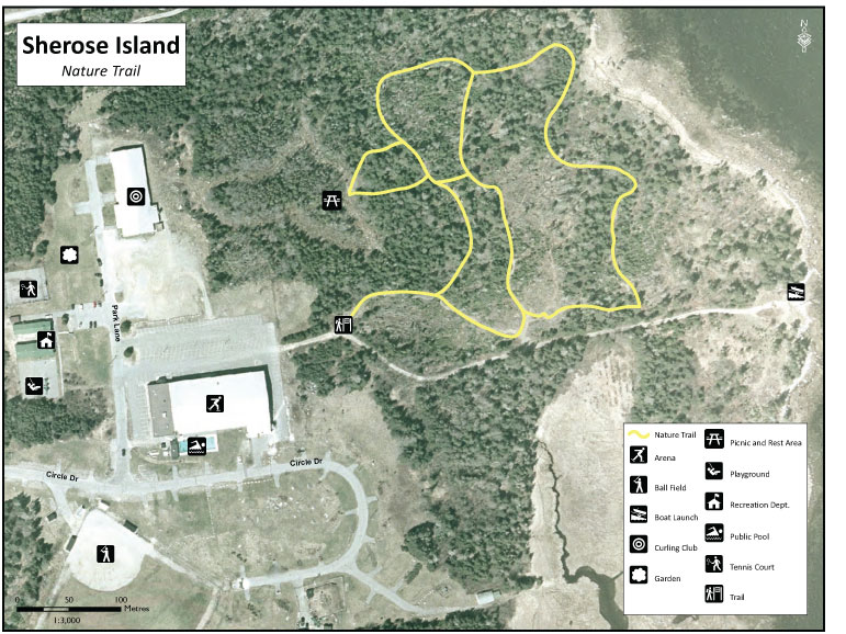
Sherose Island Nature Trail
 The Sherose Island Nature Trail is a walking trail located at the end of the Barrington Municipal Arena (12 Park Lane, Sherose Island) parking lot.
The trail was last updated in 2016
Sherose Island Nature Trail Map